Detailed Introduction to Funing County of Wenshan Prefecture
Overview
Funing County (Fùníng Xiàn) is the easternmost county-level division of Yunnan, situated in the southeast of Wenshan Prefecture. Covering 5,352 km² and home to 396,818 people (2020 census), its county seat is Xinhua Town. Bordered on three sides by Guangxi and to the south by Vietnam’s Hà Giang Province, Funing serves as a strategic gateway for trade and cultural exchange between Yunnan, Guangxi, and northern Vietnam
Geography & Climate
Funing spans elevations from 203 m along the Nanli River up to 1,851 m at Mount Muhong. Its terrain features rolling hills, karst outcrops, and fertile basins fed by tributaries of the Red River system. The county experiences a subtropical monsoon climate with an annual mean temperature of ≈19 °C, a long frost‑free period, and 1,100–1,400 mm of rainfall concentrated in May–October
Administrative Divisions
Funing is divided into 6 towns, 6 townships, and 1 Yao ethnic township:
Towns: Xinhua (新华镇), Guichao (归朝镇), Bo’ai (剥隘镇), Lida (里达镇), Tianpeng (田蓬镇), Muyang (木央镇)
Townships: Banlun (板仑乡), Gula (谷拉乡), Zhesang (者桑乡), Naneng (那能乡), Ayong (阿用乡), Huajia (花甲乡)
Ethnic Township: Dongbo Yao (洞波瑶族乡)
Ethnic Composition
About 84% of Funing’s population belongs to ethnic minorities. Major groups include:
Zhuang (≈200,000), with Min, Dai, and Yei Zhuang subgroups
Han (≈84,000)
Yao (≈36,600), including Kim Mun (Landian), Iu Mien (Daban), and Shan Yao
Miao (≈24,400), including White, Lopsided, and Red Miao
Yi (≈11,250), spanning White Yi, High‑Trouser Yi, Flowery Yi, etc.
Buyang, Gelao, and small Hui communities
Economy & Agriculture
Agriculture remains the backbone of Funing’s economy:
Staple crops: Upland rice, maize
Cash crops: Tobacco, tea, vegetables, star anise
Aquaculture: Carp and shrimp in plateau reservoirs
Cross‑border trade through Xinhua and Guichao drives commerce in fruits, timber, and handicrafts. Eco‑tourism around plateau lakes and ethnic villages is rapidly growing
Cultural Traditions & Festivals
Funing’s multi‑ethnic heritage shines in its festivals:
Longduan Festival (Zhuang): A “Valentine’s Day” courtship fair with antiphonal love songs and folk markets, held late in the 3rd lunar month
Panwang Festival (Yao): Ancestor‑worship ceremonies, livestock sacrifices, and traditional dance in Dongbo Township, mid‑autumn
Tiaogong Festival (Yi): Torch ceremonies, bronze‑drum dances, and Lusheng performances in Longmai Village, Banlun Township, 4th lunar month
Key Attractions
Gantun & Longsuo Red Army Caves (Banlun Township): Revolutionary heritage sites open free to visitors
Traditional Villages (Banlun & Guichao): Well‑preserved Zhuang, Yi, and Yao hamlets offering homestays, handicraft demonstrations, and ethnic markets
Guichao Six Scenic Spots: Karst lakes, cliff springs, and historic temples around Guichao Town
Pu Hall River & Xinhua Old Town: Riverside promenades, folk‐architecture clusters, and lively markets in the county seat
Transportation
Air: Nearest airport is Wenshan Puzhehei Airport (WNH), with regular flights to Kunming and Nanning; onward buses to Funing take ~2 hrs
Rail: Wenshan Airport Station on the Wenshan–Guangzhou Railway provides regional links; county roads connect to Xinhua.
Road: National Highway 323 and provincial highways traverse the county; air‑conditioned inter‑town buses serve all major towns
Conclusion
Funing County blends borderland commerce, rich ethnic traditions, and striking karst scenery into a vibrant frontier region. Whether exploring Red Army caves, joining a Zhuang festival, or rafting along Pu Hall River, visitors encounter the dynamic interplay of culture, history, and nature that defines southeastern Yunnan.
Guide

Amazing Balagezong Grand Canyon
6,2,2021 0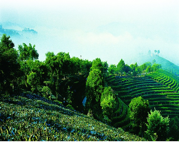
Pu’er Profile
4,5,2016 0